Pre Flight
- Ascent Rate & Burst Altitude calculator - This is a handy spreadsheet for calculating the ascent rate and burst altitude for your balloon. These numbers are needed in order for the tool below to calculate the balloon's flight path.
- Balloon Track for Windows is a software package that will project the flight path for your balloon. You tell the tool where you want to launch from, the ascent rate, the burst altitude, the descent rate and the wind data for your launch date and it models when and where your balloon should land. This is designed to give you a rough idea of where your balloon will go so you can avoid things such as your local airport and large bodies of water...such as the Atlantic Ocean :) If you have Microsoft MapPoint installed you can generate an image of the projected flight path. The green line shows the flight of the balloon during ascent and the red line is for descent. This shows us landing close to the ocean so we'll have to head west for our launch.


Payload
Our payload is pretty simple, we don't have an onboard computer so the only software application we are using is for our camera. CHDK is open-source 3rd party software that runs on several different digital cameras. We need to use CHDK to program our Canon A610 to take pictures on some set interval for an extended period of time. The default canon firmware has some time-lapse photography ability but it is limited to 100 pictures. We would like to take as many pictures as we can on a fully charged set of batteries thus the 3rd party software.
Chase Vehicle
- AGW Packet Engine - This is the software that listens to "line in" on your PC for the audio coming from your receiver. It translates the audio into a digital packet format that can be used by other windows applications.
- AGW Tracker then listens to the packets from AGW Packet Engine. These packets contain the GPS coordinates of our balloon which allows AGW Tracker to plot the location of the balloon on a map. If you have Internet connectivity you can just use google maps but if not you will need Microsoft MapPoint. We won't have Internet connectivity in our chase vehicle so we'll be using MapPoint.
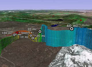
- Google Earth - Free software (mostly) that will let you do some very cool stuff in terms of displaying the path of some object based on GPS data.
- GPS Visualizer - If you give GPS Visualizer a text file with the GPS coordinates of your balloon over time it can generate several different plots of the flight path. The best results are via a Google Maps image and a Google Earth file. Here is an example of a hang glider flight path in Google Earth:
- PixGPS - I haven't used this yet but PixGPS will let you tag your pictures with GPS coordinates in the EXIF data. This way you know exactly where the picture was taken which makes it possible for tools like Google Earth to display the pictures on a map based on where they were snapped.


No comments:
Post a Comment